Football and cricket teams will have to move to pitches across Preston as work begins on £54m flood defence scheme
and live on Freeview channel 276
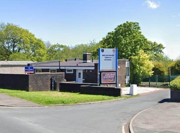
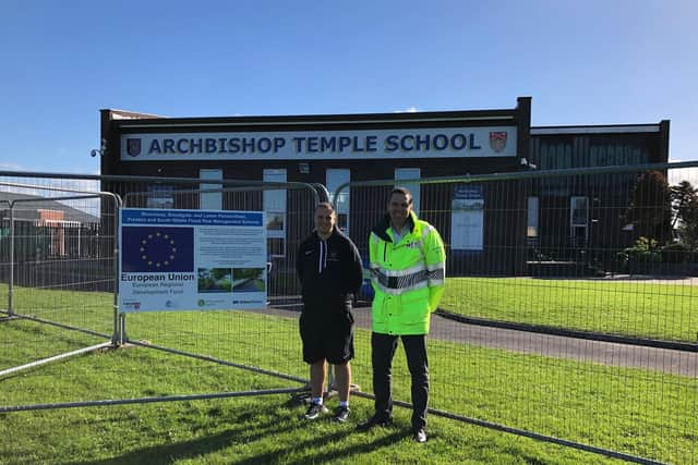
The Environment Agency has announced that it will carry out "significant" refurbishments to three football pitches and a cricket pitch at Archbishop Temple High School in St Vincent's Road, Fulwood, ready to open to the public.
These will temporarily replace sports facilities at the BAC/EE Preston Social and Sports Association in Broadgate, which will have to close while new flood defences are put in place.
Advertisement
Hide AdAdvertisement
Hide AdThe BAC/EE Preston Sports Club has a grass playing surface of approximately five acres and hosts football teams playing in the West Lancs League, the LEP Sunday League, the Central Lancs Junior Football League and The Mid Lancs Colts League.
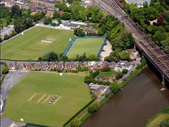

The Cricket Square consists of 12 grass wickets and an artificial wicket accommodating three senior sides and three Junior sides who all compete in the Palace Shield Cricket Competition.
The Broadgate pitches are still currently available, but work is set to begin on the flood scheme in November.
>>>Click here to see images of what the flood defences will look like.
Advertisement
Hide AdAdvertisement
Hide AdAndy Brown, flood and coastal risk manager for the Environment Agency, said: "Once the scheme is complete, everything will move back to Broadgate, and we will be left with enhanced pitches at the school. It's a legacy of the scheme, it's a double win.
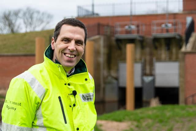
"It's right we compensate for the facilities being out of action, and we've wanted to go beyond that and make something long-lasting.
"The school have also been phenomenally helpful."
The "very substantial" funding has come from Sports England. No further details have been released.
It is not known whether the BAC/EE social club will be affected. The club has been approached for comment.
What is the flood defence scheme?
Advertisement
Hide AdAdvertisement
Hide AdIn total, there will be 9km of new flood defences to better protect 4,800 homes and 350 businesses across Preston and South Ribble.
Flood defences already in place were built at various points between the 1920s and 1980s, and are said to be “coming to the end of their life”.
>>>Click here to read why hundreds of trees have been taken down to facilitate the work.
The Environment Agency has been working alongside local councils for three years to develop the plans, which would include new defence walls and embankments.
Advertisement
Hide AdAdvertisement
Hide AdAs well as replacing old and decaying flood defences with taller and more modern materials, new walls are set to be built along the boundary of the BAC/EE Preston Social and Sports Association cricket pitch between Miller Gardens Apartments and Ribble Cottage, on the footpath to Golden Way, and outside Penwortham Methodist Church.
Glass panels will be installed in three of the new and replacement walls in the area. There will be 80cm-high glass panels on top of concrete walls between Penwortham Old Bridge and Miller Gardens Apartments, on a concrete wall on the riverside in front of the Continental pub, and a 60-80cm tall glass panel running on top of a replacement concrete wall running along Riverside Road from the Cadent Gas Pipe Bridge to Stanley Avenue.
There are also ambitious plans to create 'Ribble Sidings' - a variety of new wetland habitats created within a new network of footpaths along the South Ribble side of the River Ribble.
"Be prepared"
Mr Brown said: "Flood defences give people confidence and assurance. They make flooding less frequent, but they don't prevent them from ever happening.
Advertisement
Hide AdAdvertisement
Hide Ad"There may be a flood that is bigger than these defences, and that's why it's important that people sign up to flood warnings and look at how prepared they are in their own homes and businesses."
>>>Click here to see whether your property is at risk of flooding.
Phase one and two
Phase one and two of the flood defence work will begin on the Preston side of the Ribble next month, moving to the Penwortham side in the New Year. Mr Brown says he is confident all work will be completed on target by 2024.
Here are all the locations for these phases:
BROADGATE: Replacement of the existing concrete wall, with a new concrete wall, between Liverpool Road bridge and Penwortham Old Bridge. Existing Wall Height: 0.75 - 1.23m Proposed Wall Height: 1.20 – 1.6
Advertisement
Hide AdAdvertisement
Hide AdRIVERSIDE: A new concrete wall along the boundary of the BAC/EE Preston Social and Sports Association cricket pitch between Miller Gardens Apartments and Ribble Cottage (the two flood gates). Existing Wall Height: 0. Proposed Wall Height: 1.16 – 1.22m
RIVERSIDE: Replacement of the existing concrete wall, with a new concrete wall with glass panels on top, along Riverside highway between Penwortham Old Bridge and Miller Gardens Apartments. Existing Wall Height: 0.78 - 1.08m. Proposed Wall Height: 1.63 – 2.24m (incl. 800mm high glass panel)
RIVERSIDE: Replacement of the existing concrete wall, with a new concrete wall with glass panels on top, running on the river side of the road in front of the Continental Public House restaurant. Existing Wall Height: 0.90 - 1.09m. Proposed Wall Height: 1.78 – 2.53m (incl. 800mm high glass panel)
RIVERSIDE ROAD: Proposed replacement of the concrete flood defence wall, with precast concrete flood defence wall and glass panels on top, running along Riverside Road from the Cadent Gas Pipe Bridge to Stanley Ave (upstream end of Riverside Road). Existing Wall Height: 1.00 - 1.30m. Proposed solid Wall height: 1.70 - 2.20m (incl. 600-800mm glass panel on top)
Advertisement
Hide AdAdvertisement
Hide AdRIBBLE SIDINGS: Proposed replacement of the 1.7m flood defence embankment at Ribble Sidings with 3.5m high flood defence embankment with a 3m crest width.
The existing riverside footpath (bridleway) route will be maintained with an access ramp over the proposed flood defences. A new habitat area will be created on the dry side of the flood defence embankment.
The design includes dipping platforms which will allow people to interact with the new habitat.
MILLER PARK: A new concrete retaining wall along a ramped section of the main cycleway and earth embankment in Miller Park. Existing Wall Height: 1.09m. Proposed Wall Height: 1.90 – 2.00m
Advertisement
Hide AdAdvertisement
Hide AdPENWORTHAM METHODIST CHURCH: A new proposed pre-cast concrete flood defence wall between 0.65-2.2m tall.
There is also a proposed road ramp to raise existing road levels at the entrance to Penwortham Methodist Church. The private access road into the church and the adjacent allotments will be raised by approximately 1m.
There are also plans to partially infill the Network Rail disused underpass near the church with 1.5m high solid concrete wall.
GOLDEN WAY FOOTPATH: Proposed pre-cast concrete flood defence wall between 0.65-2.2m tall
Later phases
Advertisement
Hide AdAdvertisement
Hide AdPlanning permission will be required for works further along the Ribble.
Area 3: Frenchwood and Fishwick Bottoms
Area 4: Walton-Le-Dale (along the Capitol Centre)
Area 5: Higher Walton and Samlesbury
The Environment Agency is updating its online engagement platform for the duration of the project. This can be seen here: http://www.thefloodhub.co.uk/psr
Comment Guidelines
National World encourages reader discussion on our stories. User feedback, insights and back-and-forth exchanges add a rich layer of context to reporting. Please review our Community Guidelines before commenting.